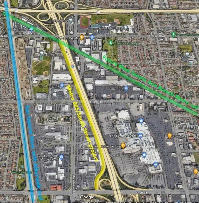
Metro and Caltrans plan to widen the 605 Freeway in the city of Cerritos, with construction anticipated this year. Though Metro claims the mile-long, $30+ million “Southbound Interstate 605 from State Route 91 to South Street Improvements” project is multimodal, the project would not add any multimodal features that aren’t already there.
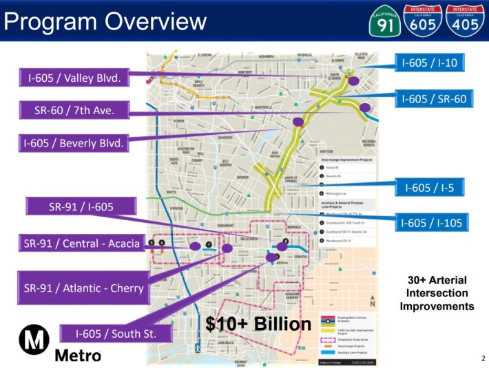
The 605/South Street project is part of two overlapping larger Metro groupings of freeway/ramp/road widening projects totaling $10+ billion:
- I-605 Corridor Improvement Project is Metro’s $5+ billion plan to widen the 605 and connected freeways: the 5, 10, 60, and 105. The 605CIP would have demolished hundreds of homes, mainly along the 5 in Downey. Metro is currently revising 605CIP designs to demolish fewer homes.
- SR-91/I-605/I-405 “Hot Spots” Program (also called I-605 Early Action Projects) is a catch-all category of Metro projects widening parts of the 605, 91, 60, as well as freeway ramps and nearby arterial intersections, preparing for 605CIP widening. See SBLA coverage of Hot Spots widening of the 91 and 60.

The 605/South project would add an approximately 0.9-mile long southbound “auxiliary lane” (basically a general purpose lane that doesn’t go past ramps) along the west side of the 605 Freeway, extending from the 605/91 connector road (roughly at Artesia Boulevard – at the West Santa Ana Branch rail right-of-way) to the end of the South Street off-ramp.
That 0.9-mile distance is telling because adding an auxiliary lane less than one mile long is exempt from full environmental review under state environmental law. Metro and Caltrans are doing a couple dozen of these categorically exempt aux lane projects in various parts of L.A. County.
A categorical exemption means very little public process. The 605/South Street project environmental document numbers just one page: a 2019 “notice of exemption” (NOE).
In 2017, the Metro board approved an 18-month $4.5-million contract for preparing the 605/South Street project designs. Metro’s contractor, TransSystems, notes that the work has been completed. But there is no Project Report nor any other project-specific documents available online – beyond the one-page NOE. (Last week Streetsblog requested the Project Report from both Metro and Caltrans, but neither had provided it at press time.)
There is a brief description of the 605 South Street project in a 2020 Metro staff report (from an approval for $5.5 million in construction support services for two 605 Hot Spots freeway projects):
The I-605 Southbound South Street off-ramp project includes freeway exit lane realignment and addition of a fourth lane at the intersection with South Street. A retaining wall with an approximate length of 1570 feet will be constructed along the west shoulder/embankment of the ramp, and traffic signs and signals will be constructed to accommodate the new configuration.
The project will include widening 605 Freeway bridges over 183rd Street and Studebaker Road. It appears to end just short of the 605 bridge over the West Santa Ana Branch. That staff report states that the 605/South Street project will either not require any right-of-way acquisitions, or will only require minimal right-of-way.
Last Month, in a presentation at the Gateway Cities Council of Governments SR 91/605/405 Technical Advisory Committee (605TAC), Metro staff reported that the 605/South Street project construction would be put out to bid in January 2023, with construction anticipated in Fall 2023. On January 31, Metro spokesperson Patrick Chandler noted that the project construction has not been advertised yet.
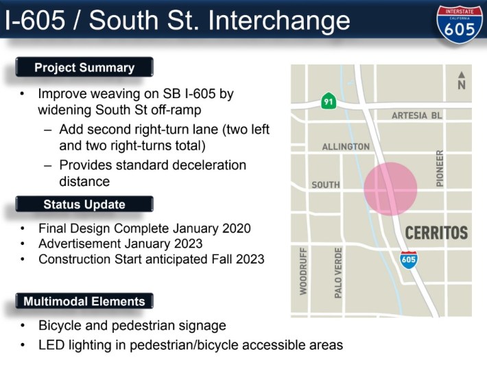
Chandler wrote that project construction is anticipated to cost “about $25 million.”
That January 605TAC presentation also announced new “Multimodal Elements” for several Metro freeway expansion projects. For three 605 Hot Spot freeway/ramp/road widening projects (South Street, Valley Boulevard, 60/7th Ave.), Metro added the same multimodal components text: “bicycle and pedestrian signage” and “LED lighting in pedestrian/bicycle accessible areas.”
This begs the question: what part of this mile-long freeway lane is “bike/ped accessible”?
Streetsblog inquired to Metro as to what the multimodal elements of 605/South Street project are and what areas would be accessible on foot or bike. Chandler responded that:
…this project did not include bike-accessible areas because ROW [right-of-way] is constrained in that area. Metro would have had to acquire property to accommodate a bike lane. Ped improvements include curb ramps and signals at the intersection of SB [southbound] off-ramp and South St. will be reconstructed to meet ADA standards.
When Streetsblog inquired as to what bike/ped signage would be included, Chandler responded, “Traffic Direction Signs.” This isn’t very clear, and doesn’t seem to pertain to biking or walking.
From Chandler’s responses it is pretty clear that the project includes no transit or bike features, and, for pedestrians, the project would merely put back in existing off-ramp walk signals and curb ramps where it widens an offramp.
This isn’t multimodal. Metro’s new “multimodal” approach to highway widening appears to be: don’t take any public input, completely ignore transit riders, slap a couple of isolated ineffective (perhaps nonexistent) bike/walk components in, and start touting the project as “multimodal.” Metro made similarly hyperbolic multimodal claims on the recently-approved half-billion dollar widening of the 57/60 freeways.
What is astonishing is that is not that difficult to find room for multimodal improvements in and adjacent to this project’s footprint. The project intersects with the future West Santa Ana Branch rail line; it is less than a mile from the planned Pioneer Station WSAB terminus. It’s less than a quarter mile from the San Gabriel River bike/walk trail.
Below are some potential basic multimodal components that Streetsblog could imagine being added to the 605/South Street project. Some of these are within the 605 project footprint; some are nearby. None require right-of-way acquisition.
Possible bike facilities
- Metro could add bike lanes to Studebaker, including directly under a bridge Metro would widen. Between South Street and Artesia Boulevard, bike lanes could be installed very easily, without removing anything – no loss of parking, no change to travel lanes. The bike lanes could extend south to Del Amo Boulevard or 195th Street, both of which connect to the river trail.
- These are less easy, but Metro could also add bike lanes to 183rd Street (in the project footprint) and South Street (the south end of the project). The 183rd Street lanes could connect to the river trail and to Artesia’s WSAB bike path. The South Street lanes would close a gap. Space is tighter on these streets, but narrowing driving lanes and bike lanes to minimums would fit.
- At the top end of the project, Artesia Boulevard (a city designated bike route) could accommodate bike lanes between Studebaker and the river.
- It’s not in the project footprint (more on this below), but the parallel facility a quarter mile west that bicyclists already use heavily is the San Gabriel River path. Metro should work with the County Public Works to determine what is allowed/needed on this part of the river. Improvements could include: basic resurfacing of worn pavement, landscaping, and/or welcoming entrances (like Emerald Necklace mini-parks upstream, for example). One potential entry point site could be Cerritos’ Liberty Park at South Street.
Possible transit facilities
- The 605/South Street project is adjacent to Los Cerritos Center mall, which serves as a de facto transit hub for Metro, Long Beach Transit, OCTA and other bus lines. There are more than a dozen nearby transit stops. Nearly all lack shade cover; some lack seating.
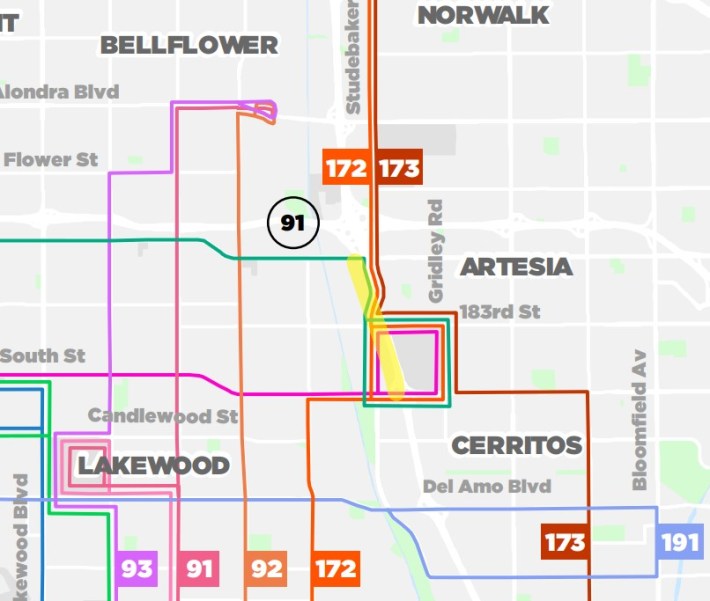
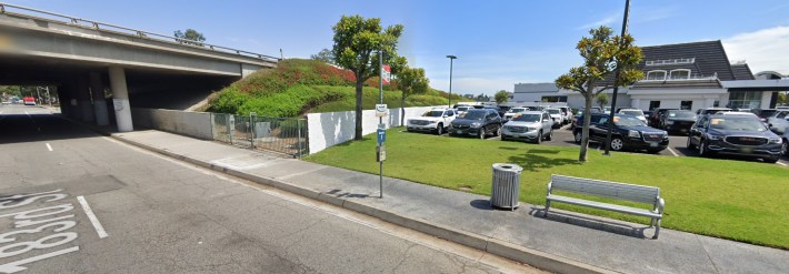
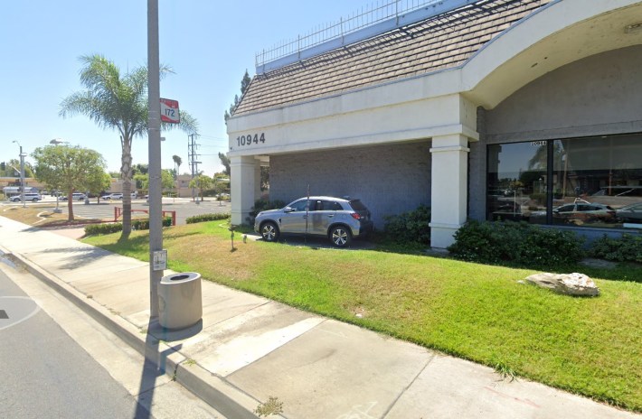
Adding basic seating and shade (structures, trees – like nearby stops on 183rd) would start to address transit rider needs. But, don’t just take Streetsblog’s suggestions. Metro’s multimodal project team should work with Metro’s own transit operations staff, Long Beach Transit, and the city of Cerritos, etc. to do some sort of basic transit needs assessment in the project vicinity. Beyond just improved bus stops, there may be opportunities for transit speed improvements – such as queue jumpers, bus lanes, and/or adding all-door boarding to Metro buses?
- It’s probably too much to ask for, but what if this 605 project, which intersects the West Santa Ana Branch, were to lay some of the groundwork for the future WSAB rail line? Is there early construction activity – like utility relocation, soil clean-up, grading – that can save time/money later? How about adding some of the planned bike/walk path in a wider part of the WSAB right-of-way? The path may not fit under the 605, but it might make sense from, say, Studebaker to Gridley Road?
Possible walk facilities
- Within a block or two of the 605, many crosswalks have worn out, some entirely: 183rd/Studebaker, 183rd mall entrance, Studebaker/Auto Square, South St./Studebaker, South St. mall entrance, etc. Metro could re-install crosswalks, possibly upgrade to high-visibility zebra crosswalks.
- Less than a quarter mile from the project, Metro could add sidewalks that are missing on Dumont Avenue.
If Metro wants truly multimodal projects, then the agency needs to do some homework. Talk to agencies, cities. Get public input. 605/South Street is not a difficult project to add multimodal components to. It is disappointing that Metro hasn’t yet made the effort.
Back in 2021 Metro CEO Stephanie Wiggins reorganized the Metro Highway Program in order to shift the agency away from single-purpose freeway projects and toward multimodal ones. Metro highway program staff have had more than 14 months to make the 605/South Street project multimodal. They apparently looked around and couldn’t find any multimodal elements that they could add.
And lest you think all of Metro acts like this – no, they don’t. When Metro builds a rail line, they deliberately incorporate numerous new features for drivers. Rail projects include plenty of road widening (street dedications), expensive grade separations (mandated by local jurisdictions intent on keeping car traffic moving), street crossing features (gate-arms), new traffic lights, plus park-and-ride lots/structures. Can anyone imagine a Metro rail project responding to driver concerns simply with signage? That’s pretty much what Metro highway staff are planning to do to transit riders, pedestrians, and cyclists – in Cerritos.
And lest you think Metro freeway widening projects are strictly limited to looking just inside their own footprints – no they aren’t. Metro’s freeway Hot Spots program [see page 4] funds widening arterial streets in numerous cities – Artesia, Bellflower, Cerritos, Lakewood, etc., etc. – all due to tenuous ties to nearby freeways. Hot Spots includes widening streets more than a mile from freeways. Even Metro’s own freeway projects don’t stay just within the freeway right-of-way; the 57/60 Freeway widening Metro approved last month includes street widening extending more than a half-mile drive from the freeway itself.
When Metro staff approach a freeway project, they ask “how far can we stretch this widening?”
When the same staff approach a “multimodal” project, they look narrowly at just the freeway footprint (where they fail to find opportunities that are there), then they throw their hands up and say “we can’t do multimodal here.”
Metro’s insistence that the 605/South Street project “did not include bike-accessible areas because right-of-way is constrained in that area” is Metro’s failure to look at a broader corridor, the way Metro does for bus, rail, walk or bike projects. Metro should send the 605/South Street project back to the drawing board to incorporate true multimodal elements.

